Turn complex data into actionable insight
Smarter decisions and control with Vision interactive GIS tools.
Our powerful GIS component, integrated within Vision App Maker, transforms geographic data into clear, interactive maps that help organizations visualize patterns, make informed decisions, and plan with precision.

Effortlessly explore and interact with a wide range of geographic data layers tailored to your needs.
From zoning regulations and land use classifications to infrastructure networks and environmental protection zones, our platform gives you a comprehensive, real-time view of your area. Built for planners, engineers, municipalities, and decision-makers, our interactive layer system makes it easy to see the connections, spot trends, and act strategically.

Stay ahead with live, accurate, and automatically updated geospatial data. Our platform seamlessly integrates real-time information from a wide variety of sources—ensuring your maps and dashboards always reflect the latest conditions on the ground.
- Live Data Feeds – Ingest data from traffic systems, public transport, weather services, and emergency alerts.
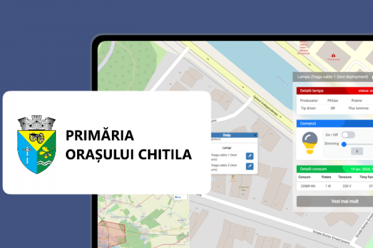
- IoT & Sensor Connectivity – Monitor smart city infrastructure like streetlights, water meters, air quality sensors, parking sensors, and waste bins in real time.
- Database Synchronization – Connect to internal and external databases
- Instant Map Updates – Automatically refresh layers, indicators, and KPIs without manual intervention.
- Alerts & Thresholds – Configure triggers for anomalies, thresholds, or events to support rapid response and automation.
From smart cities to utilities, environmental monitoring to emergency services, our real-time integration capabilities give you the power to respond faster, plan smarter, and operate more efficiently.

Work smarter with an intuitive interface designed for everyone—no GIS expertise needed. Our platform puts powerful spatial tools in the hands of any user, making data exploration and decision-making seamless.
- Clean, Modern Design – Navigate maps and tools effortlessly with a responsive, clutter-free layout.
- Drag-and-Drop Layer Management – Easily toggle, rearrange, and customize map layers with simple gestures.
- Smart Filtering – Apply filters by location, time, category, or value to instantly refine what you see.
- Measurement Tools – Quickly measure distances, areas, and perimeters with built-in tools.
- Search & Pinpoint – Locate addresses, assets, parcels, or points of interest instantly with predictive search.
- Mobile-Ready – Access full functionality from desktops, tablets, or smartphones—perfect for field teams and mobile inspectors.
- Personalized Dashboards – Each user can tailor their workspace with saved views, preferred layers, and shortcuts.
Whether you're a city planner, facility manager, analyst, or community stakeholder, our interface empowers you to interact with complex data as easily as using a map app.

Seamlessly collaborate across teams, departments, or the public—with full control over access and sharing. Our GIS platform is built to support transparent, efficient collaboration whether you're working within an organization or engaging with the community.
- Real-Time Collaboration – Enable multiple users to view and work on the same map simultaneously with real-time updates and change tracking.
- Public & Private Portals – Publish selected maps and data layers on a public portal while keeping sensitive information restricted.
Supports dynamic, customizable layers (vector, raster, 3D) that users can toggle on/off—stunning for visualizing utilities, infrastructure, terrain, and asset data in real time
Enables live updates via geocoded data synchronization, combined with offline map downloads for fieldwork—ideal for remote site operations where connectivity is unreliable
Built-in search, filtering, and interactive pop-ups let users locate addresses, features, or assets instantly, with contextual attribute data and visualizations upon clicking map points
Includes tools for buffers, drive‑time analysis, demographic radius mapping, and heatmaps, plus integrated reporting capabilities—empowering data-driven decision-making
Ensures maps render seamlessly on desktop, tablet, and mobile platforms—built for responsiveness and optimized interface experience across devices
Offers robust APIs and SDKs (e.g., Leaflet, ArcGIS JS) to embed interactive maps in web portals or connect with CRM, ERP, or field service apps—perfect for tailored environments